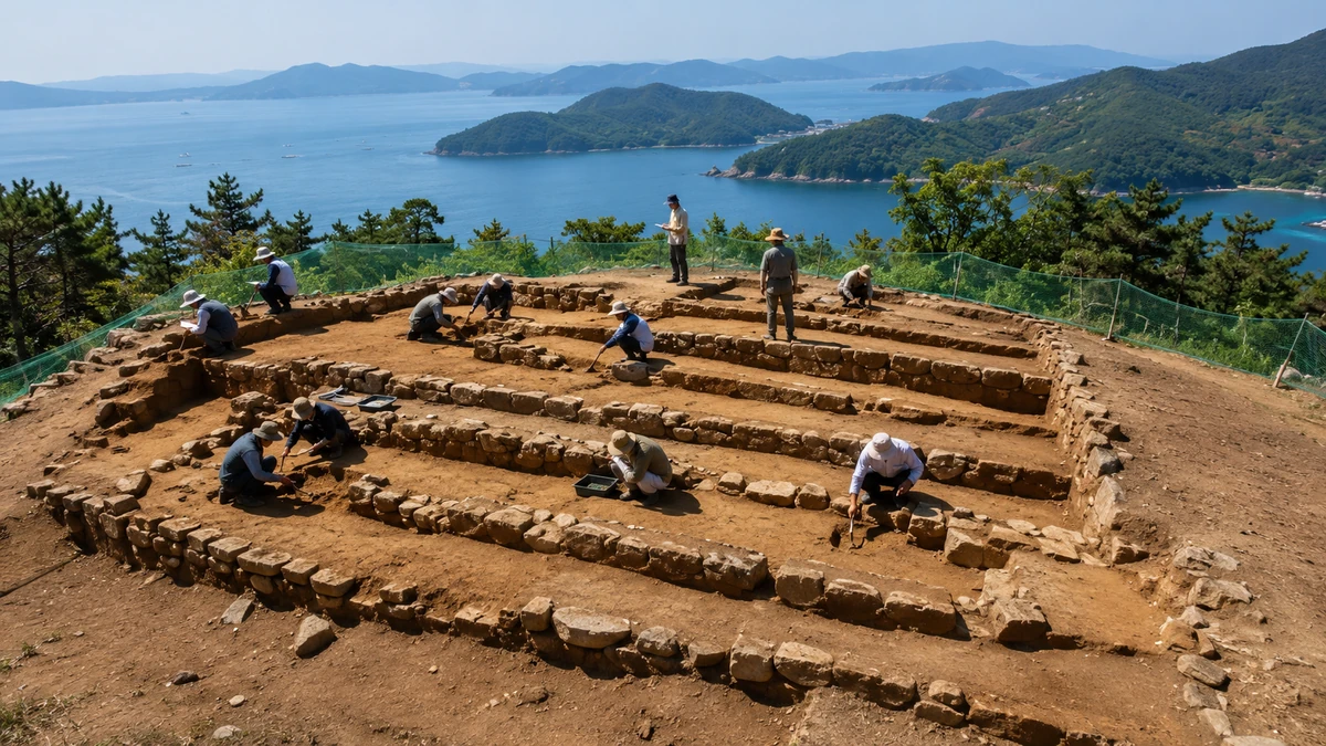
A coastal site in South Korea enters the heritage spotlight
South Korean officials have taken a formal step toward protecting a little-known medieval site on the country’s southern coast, underscoring how even modest-looking terrain can reshape the way historians understand a nation’s past. Gyeongsangnam-do, the provincial government in South Gyeongsang Province, said this week that it has issued a preliminary notice designating Namhae Daejanggunji as a provincial monument, citing the site’s value in interpreting the movements and resistance of the Sambyeolcho, a military force that became associated with one of late Goryeo Korea’s most dramatic periods of upheaval.
The announcement is not a final designation. That distinction matters. In South Korea’s heritage system, a preliminary notice means the government has publicly declared its intent to move forward after reviews by specialists, but the administrative process is still underway. For readers in the United States, it is somewhat similar to a local or state government beginning the formal process to landmark a historically significant property before all final approvals are complete. It signals official recognition of value, but it is not the last word.
Even at this stage, though, the move is notable. The province said the Namhae site is important not only for understanding the Sambyeolcho’s anti-government and anti-Mongol struggle in the late 13th century, but also for interpreting military and maritime activity along Korea’s southern coastline during the late Goryeo period. That broader framing is one reason the news has drawn attention from historians and heritage officials alike. Instead of treating the Sambyeolcho story as a sequence of isolated battles or political events, the province is emphasizing geography: how islands, coastlines and fortified bases worked together in a mobile, seaborne conflict.
At the center of the site’s significance is a five-tier terraced landform identified through excavation. Researchers also found that the overall spatial layout bears similarities to Yongjangseong in Jindo, a better-known Sambyeolcho stronghold in southwestern Korea. Officials say that comparison broadens the interpretive value of the Namhae ruins, because it allows scholars to examine multiple Sambyeolcho-related sites through a shared architectural and spatial lens rather than relying only on written chronicles.
That may sound technical, but it gets to the heart of how archaeology works. In many cases, especially at older military sites, the story is not preserved in standing walls or dramatic artifacts. It survives in the arrangement of ground levels, the logic of defensive placement, the shape of a platform and the relationship between land and sea. In other words, the historical record is often written into the landscape itself.
Who were the Sambyeolcho, and why does this still matter?
For Americans unfamiliar with Korean history, the Sambyeolcho are not a household name. But in Korea, they occupy a distinctive place in the national historical imagination. They are generally remembered as an elite military force of the Goryeo dynasty that, after a period of political turmoil and Mongol pressure, continued armed resistance even after the royal court sought a settlement. Their rebellion in the 1270s unfolded across islands and coastal strongholds, making it one of the clearest examples in Korean history of a conflict defined by mobility, maritime strategy and contested legitimacy.
The Goryeo dynasty, which ruled Korea from 918 to 1392, gave the modern name “Korea” its linguistic roots. By the 13th century, however, Goryeo was under severe strain from Mongol invasions and internal power struggles. The Sambyeolcho emerged from this world of military crisis. While scholars debate aspects of their role and motives, they are widely associated with continued resistance after the central court’s position shifted. In broad terms, they have often been portrayed as fighting on after official policy moved toward accommodation.
That historical memory carries weight in South Korea today, where resistance against foreign domination often resonates deeply in public culture. Yet historians also try to separate legend from evidence. That is one reason sites like Namhae Daejanggunji matter. They can help ground a story that is sometimes told in sweeping, almost cinematic terms. Rather than relying only on patriotic interpretation or literary accounts, archaeologists can ask more concrete questions: What did a Sambyeolcho base look like? How was it organized? What kind of terrain did it use? How did people move through it? How did coastal installations support military survival and communication?
Those questions would be familiar to anyone who has visited Civil War battlefields in the United States or historic military forts along the Atlantic coast. Often, the power of a site does not come from monumental architecture alone. It comes from the chance to see how topography shaped events: a ridge that controlled movement, a harbor that enabled supply, an earthen platform that organized defense. Namhae Daejanggunji appears to fit that pattern. Its importance lies not in grandeur, but in strategic form and preservation.
The Sambyeolcho story also helps explain why provincial heritage decisions in Korea can attract national attention. In a country where dynastic history, regional identity and modern cultural memory overlap, even local sites can illuminate defining historical themes. A place on a southern island or coastline may help explain how resistance spread, how military networks operated and how the sea functioned not as a boundary, but as a corridor.
What archaeologists found at Namhae Daejanggunji
The most concrete finding highlighted by officials is the five-stage terraced structure uncovered at the site. In plain terms, archaeologists identified a piece of land deliberately shaped into five stepped levels. That sort of terracing suggests intentional planning rather than a casual or purely natural formation. It indicates that people in the late Goryeo period organized space for a specific purpose, even if the precise function of each level has not yet been definitively established.
This point is crucial. Archaeology often operates in degrees of certainty. The evidence can show that a site was constructed in a purposeful way and that it shares characteristics with known military or administrative installations. But it does not always allow scholars to say exactly which building stood on which terrace, or who occupied each part, or what took place there on a given date. Responsible interpretation requires distinguishing between what has been confirmed and what remains open to further study.
According to the provincial government, the Namhae site’s spatial organization resembles that of Yongjangseong in Jindo, a site long connected with the Sambyeolcho. That does not mean the two places were identical. Heritage officials were careful not to claim a perfect match. Instead, the significance lies in comparative analysis. If separate sites tied to the same historical network share a similar layout, that can strengthen arguments about how the Sambyeolcho built, occupied and defended their bases.
For non-specialists, one useful analogy might be the way archaeologists in the Mediterranean compare fortifications across Roman or Byzantine sites to identify common strategic patterns. A single wall or platform may not say much by itself. But when similar design logic appears at multiple locations, a larger historical picture starts to emerge. In the case of Namhae Daejanggunji, that picture points toward a coastal stronghold that may help explain movement, command structure and maritime activity during the late Goryeo period.
The province said experts assessed not only the site’s historical value, but also its state of preservation and the need for formal protection. That indicates the decision was not based on historical romance or local pride alone. Heritage designations in South Korea, as elsewhere, typically require weighing whether a site still retains enough original character to merit protection and whether legal recognition can help prevent future damage.
That is especially important for archaeological landscapes, which are often vulnerable precisely because they do not always look spectacular to the untrained eye. A stepped embankment or leveled platform can be mistaken for ordinary terrain. Without formal recognition, such places can be eroded by development, road work, agricultural change or piecemeal alteration. Once the spatial relationships are lost, the site’s interpretive value can disappear even if no single “artifact” is visibly removed.
Why the sea matters as much as the land
One of the most interesting parts of the announcement is the emphasis on military and maritime activity along the South Sea coast. That wording pushes readers to think of the Sambyeolcho not simply as rebels holding out in one fortress, but as participants in a wider seaborne network. In the Korean context, the South Sea refers to the complex coastal region of islands, channels and inlets that stretches across the southern edge of the peninsula. It is a landscape where control of water routes could be as important as control of roads.
For American readers, a comparison might be the role played by bays, barrier islands and coastal fortifications in early American wars, where naval access, supply lines and shoreline geography shaped what armies could do. The sea is not empty space on a map. It can be a highway, a shield, an escape route and a source of vulnerability all at once. The Sambyeolcho’s historical footprint makes more sense when viewed through that lens.
That is why Namhae matters. Namhae is an island county in South Gyeongsang Province, known today more for scenic coastlines and rural communities than for being a centerpiece of mainstream Korean history textbooks. But geographically, it sits in a region where maritime movement would have been central to any late medieval military strategy. A site there can help historians map not only where people fought, but how they moved, provisioned themselves and linked one stronghold to another.
Officials specifically said the site helps interpret the Sambyeolcho’s “movement and resistance,” as well as broader military and maritime activities along the southern coast. The pairing of those terms is significant. It suggests the site’s meaning is not confined to a single dramatic event. Rather, it may illuminate a system: the relationship between temporary control points, fortified positions and the sea lanes connecting them.
That approach also reflects a broader trend in archaeology and historical scholarship, which increasingly treats landscapes as integrated systems instead of isolated monuments. A fortress is not just a fortress; it is part of a network of visibility, access, resources and communication. By comparing Namhae Daejanggunji with Jindo’s Yongjangseong, scholars may be able to better understand what kinds of sites the Sambyeolcho relied on and why those places mattered in a coastal insurgency.
In that sense, the Namhae announcement contributes to a larger conversation about Korean history that global audiences sometimes miss. Much popular understanding of Korea abroad focuses on royal palaces in Seoul, Buddhist temples or, more recently, the country’s global pop-culture exports. But Korean history was also shaped by regional coastlines, secondary strongholds and local terrains that connected political decisions to daily survival. This site belongs to that less internationally familiar, but no less important, historical geography.
What “preliminary designation” means in South Korea’s heritage system
The procedural language in the announcement may seem dry, but it is one of the most important parts of the story. Gyeongsangnam-do did not say the site has already been fully designated as a provincial monument. It said the site has been placed under notice for designation. That distinction matters for accuracy, and it is the kind of detail that often gets blurred in quick headlines.
In heritage administration, a preliminary notice is essentially a public signal that the site has passed an important threshold of official review. Experts have conducted field inspections and evaluations. The government has determined that the site appears to have enough historical significance, integrity and preservation value to warrant formal protection. But the full legal process has not yet run its course.
American readers might compare this to a city landmarks commission or state historic preservation office publicly proposing protected status for a site before the final vote or administrative ruling. The proposal itself can carry real significance. It tells developers, residents, scholars and the public that the government sees this place as more than a vacant lot or local curiosity. It is a place whose historical meaning deserves official scrutiny and, potentially, legal safeguarding.
That is also why it would be misleading to treat the announcement as a sudden “discovery.” The province’s own explanation makes clear that the current move rests on accumulated excavation results and expert review. In other words, the story is not that an unknown ruin has abruptly appeared out of nowhere. The story is that a body of evidence has matured to the point where formal conservation discussions have entered a new stage.
This may seem like bureaucratic nuance, but in heritage reporting it is essential. Public understanding of archaeology can easily become distorted when every administrative milestone is framed as a dramatic breakthrough. The more sober reality is often more interesting: years of fieldwork, comparative study and preservation assessment gradually lead to a point where a government decides the site deserves special protection. That is the stage Namhae Daejanggunji has now reached.
It also means that, for now, attention should remain focused on documented historical value rather than tourism speculation. The province did not announce a museum project, festival plan or opening date for visitors. At this stage, the emphasis is on the site’s historical significance, preservation condition and the need for monument status. That is a reminder that heritage policy, at its best, puts conservation before commercialization.
A regional site with national and global relevance
One reason this story travels beyond local Korean news is that it shows how historical meaning can reside in places far from capital cities and famous monuments. For international audiences, Korean history is often encountered through Seoul’s palaces, UNESCO-listed temples or globally recognized culture such as K-pop and Korean film. Those are important entry points, but they can unintentionally flatten the country’s historical landscape.
Namhae Daejanggunji offers a different perspective. It suggests that the Korean past is also preserved in regional topography, in terraced ground forms and in coastal sites whose importance comes from their relationship to movement and strategy. This is a familiar concept in world history. In many countries, some of the most revealing historical places are not the grandest ones, but the sites that help explain how power actually operated on the ground.
That matters especially in a country like South Korea, where rapid industrialization and urban development have transformed the landscape within living memory. The act of recognizing and protecting lesser-known sites is, in part, a statement about what kind of past is worth keeping visible. It is also a statement that regional history is not secondary history. A site on the southern coast can be central to understanding a formative national episode.
There is also a broader heritage lesson here. The value of a site does not depend solely on treasure-like artifacts or picturesque ruins. It can depend on layout, comparison and preservation. The five-tier terraced landform at Namhae is meaningful because it preserves evidence of deliberate human organization. Its similarity to another Sambyeolcho-related site matters because comparison is one of the strongest tools historians have for moving from isolated findings to larger interpretations.
For readers outside Korea, that may be one of the most accessible ways to understand the news. Think less of a single spectacular ruin and more of a key puzzle piece. Alone, it offers clues. In relation to other sites, documents and geography, it helps reconstruct a historical network. That network, in turn, sheds light on how a medieval Korean military force navigated a period of political fracture and foreign pressure.
At a time when heritage debates around the world often revolve around who gets remembered, which landscapes are protected and how history is explained to the public, the Namhae case feels quietly significant. It shows a government moving to preserve not just a name from a chronicle, but a physical space that can still teach. It also shows the discipline required to do that responsibly: distinguish what has been excavated from what remains speculative, and protect the site before turning it into a narrative product.
Preservation before mythmaking
If the designation process moves forward, Namhae Daejanggunji is likely to attract more public interest. That can be a good thing. Greater visibility can lead to better funding, wider educational use and a stronger appreciation for regional history. But increased attention also brings a familiar risk: the temptation to oversell what is known.
Officials and scholars have been relatively careful so far. The confirmed points are significant on their own. The site is associated with the late Goryeo-era Sambyeolcho. Excavation revealed a five-tier terraced landform. Its spatial organization has parallels with Yongjangseong in Jindo. Experts reviewed its historical value, preservation condition and need for protection. The province believes it is important for understanding the Sambyeolcho’s movements and resistance, as well as military and maritime activity along the southern coast.
What has not been established, at least from the information made public so far, is a complete map of the function of each terrace or a fully detailed reconstruction of daily operations at the site. That restraint is not a weakness. It is the mark of serious historical work. Archaeology is strongest when it draws a clear line between evidence and imagination.
That point may be particularly relevant in South Korea, where local governments often see heritage as part of community identity and regional revitalization. There is nothing inherently wrong with that. Historic sites can indeed become educational destinations and sources of local pride. But the first obligation remains preservation of the original context. In a landscape-based site like Namhae Daejanggunji, even small alterations can erase the very spatial relationships that make the site valuable.
For that reason, the current moment is less about tourism than stewardship. The real significance of this week’s move lies in the official recognition that this coastal site deserves to be studied, protected and interpreted with care. If future public access or programming comes later, it will need to be built around that principle, not the other way around.
In the end, the announcement from South Gyeongsang Province is a reminder that history often survives in understated forms. A terraced hillside, a preserved spatial pattern, a comparison with another stronghold across the water — these may not produce the instant visual drama of a palace or temple, but they can reveal the workings of a society under pressure. For South Korea, that means a deeper understanding of the Sambyeolcho and the maritime world of late Goryeo. For global readers, it is a chance to see how a regional archaeological site can open a window onto a larger human story: how people organize space, resist power, move across water and leave traces that centuries later still shape the historical record.
Comments
Post a Comment