
A windy pause eases on South Korea’s best-known island
The immediate threat from strong winds has eased across broad stretches of Jeju, South Korea’s best-known island destination, in a development that signals a return toward normal daily routines for residents and travelers alike — though not a full all-clear for every kind of outdoor activity.
South Korea’s weather agency said it lifted strong wind advisories for 10 areas of Jeju at 3 p.m. on the 20th, according to Yonhap News Agency. The affected zones included Jeju’s mountainous interior, mid-elevation communities in both Jeju City and Seogwipo City, eastern, western, northern and southern districts across the island, and Chuja Island, a smaller island group that sits between the Korean mainland and Jeju.
For American readers, it may help to think of this less as a simple forecast update and more as the easing of a public safety signal that shapes daily decision-making. In South Korea, weather advisories are not background information tucked between sports scores and the weekend outlook. They function more like practical civic guidance, the kind that can influence ferry plans, hiking schedules, roadside safety, deliveries, fishing activity and even whether people feel comfortable setting out on routine errands.
That is especially true in Jeju, a place often marketed internationally for its beaches, volcanic landscapes and resort appeal, but which in daily life operates like a weather-sensitive island community. The lifting of a wind advisory there matters not only to tourists with scenic itineraries, but also to farmers, drivers, shopkeepers, harbor workers and families navigating a landscape where mountain, coast and open sea sit unusually close together.
Even so, the announcement does not mean the weather has become harmless. It means conditions no longer meet the threshold for a land-based strong wind advisory in those specified areas. In plain English: the risk has diminished, not disappeared.
Why Jeju’s geography makes weather more complicated than it looks
To people who have never visited, Jeju can sound like a single, compact island destination — the South Korean equivalent of a vacation postcard. But its weather is often far more variable than outsiders expect, and the agency’s advisory map reflects that complexity.
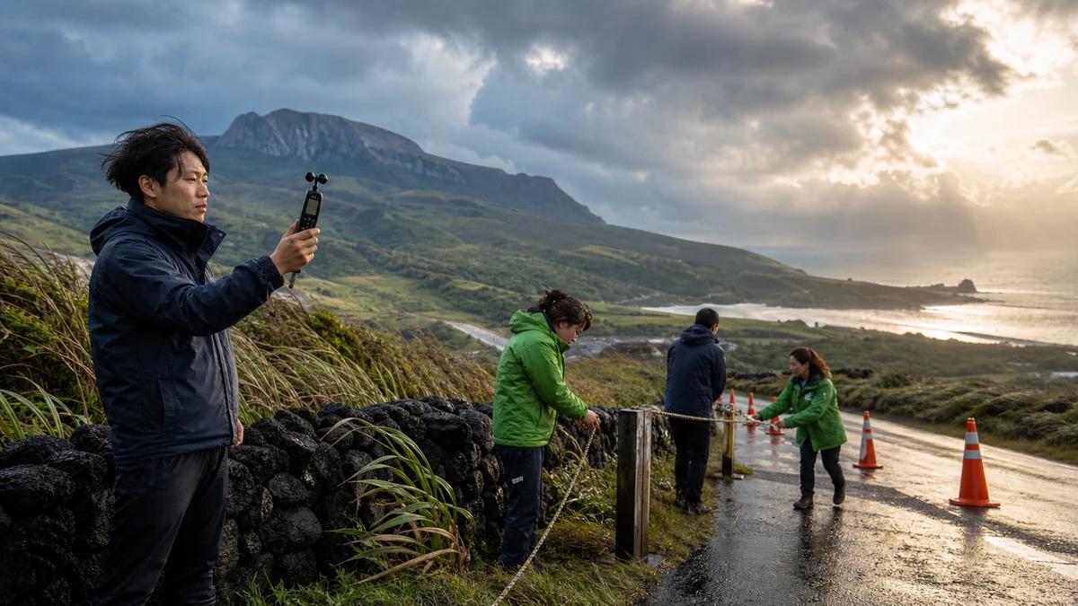
At the center of the island is Hallasan, South Korea’s tallest mountain, a dormant volcano whose elevation shapes wind, temperature and precipitation patterns across Jeju. Around it are what Koreans call the “mid-mountain” or “mid-elevation” zones, transitional areas between the coastal towns and the steep interior. Those districts can experience different conditions from the shoreline just a short drive away.
That geographic distinction matters because the advisory that was lifted did not apply to just one exposed summit or one fishing village. It covered mountain areas, mid-elevation communities and coastal population centers together. That suggests a broad moderation in conditions across multiple parts of island life, from inland roads to urban neighborhoods to areas near the sea.
For American audiences, an imperfect but useful comparison might be Hawaii, where one island can contain sunny beaches, rain-soaked slopes and wind-battered ridges within a relatively small area. Jeju has a similar reputation in South Korea as a place where topography can make the weather feel locally specific and fast-changing. A forecast that improves in one zone does not always translate instantly into comfortable or safe conditions in another.
That is part of why official advisories matter so much. They break the island into smaller operational units instead of treating Jeju as a single block on a national weather map. In practical terms, that can help residents decide whether to secure outdoor structures, whether to drive coastal routes with extra care, or whether conditions for walking, hiking or loading cargo have meaningfully improved.
What exactly was lifted — and what was not
The key distinction in the latest update is between land and sea. The strong wind advisory over the identified parts of Jeju was lifted effective at 3 p.m. But the surrounding waters were not all put on the same timetable.
The weather agency also announced the lifting of a high waves advisory for waters off northern Jeju, but that change was scheduled to take effect later, at 5 p.m. That two-hour gap may sound minor, yet it captures something important about how maritime weather works around the island: calmer conditions on land do not necessarily mean the sea has settled at the same pace.
Other nearby waters remained under wave-related alerts on different schedules. According to the summary, advisories had been in effect since late on the 19th for some offshore waters to the southwest and southeast of Jeju, while other coastal waters off the island’s west, south and east had separate advisory timings beginning early on the 20th.
For a U.S. audience, this is similar to the difference between hearing that windy conditions have eased in a beach town while small-craft warnings or rough surf advisories remain in place offshore. The experience on the boardwalk, the marina and open water can differ sharply even when they belong to the same region on a map.
That nuance is particularly important in Jeju because so much of island movement and recreation happens near the coast. Visitors may hear that an advisory has been lifted and assume hiking trails, ferry approaches, cliffside roads and seaside walkways are equally back to normal. But weather agencies separate these categories for a reason. Air may feel calmer in town while swells, gusts or choppy conditions remain significant near ports and exposed shorelines.
So the latest change should be read as a narrowing of risk rather than a blanket reset. It improves the outlook for daily life on land, but it does not erase the need to check marine forecasts, port notices or local guidance before activities tied closely to the ocean.
How weather advisories function in everyday Korean life
One of the more revealing aspects of this story is not just the forecast itself, but the role forecast alerts play in South Korean society.
In the United States, weather warnings vary widely in how people absorb them. A hurricane warning in Florida or a tornado warning in Oklahoma can prompt immediate action, while a windy-day advisory elsewhere might barely register beyond a mention on local TV. In South Korea, where population density is high and transportation systems are tightly interconnected, official weather advisories often serve as highly practical public information. They can influence decisions in schools, businesses, transportation hubs and households within a short window.
That is especially true in coastal and island regions. A strong wind advisory can affect whether outdoor fixtures need reinforcement, whether drivers should use caution on exposed roads, whether coastal pedestrians should avoid certain routes, and whether local governments or building managers need to inspect loose materials. For visitors, it can influence the wisdom of scenic drives, summit hikes, coastal photography stops or boat-related excursions.
The language of “lifting” an advisory, then, does not just mean “the weather is better.” It means the government’s formal assessment of risk has shifted below a threshold that previously called for heightened attention. That threshold-based system is important in a country where people are accustomed to reading official alerts closely and adjusting plans accordingly.
Another detail that may be unfamiliar to foreign readers is the difference between the announcement time and the effective time. In this case, some advisories were announced at 3 p.m. but took effect later. That distinction may appear bureaucratic, but it is operationally useful. It gives transport operators, local officials and the public time to interpret and act on the update. It also reflects the fact that weather improvement does not happen like a light switch. Conditions can transition unevenly across areas, especially in coastal and offshore zones.
Seen this way, the Jeju advisory update is not a trivial item about a breezy afternoon. It is a small example of how weather information becomes part of the infrastructure of ordinary life in South Korea.
Jeju’s tourism image often hides its working-island reality
For many Americans and other English-speaking travelers, Jeju is known first as a leisure destination. It is often described as South Korea’s honeymoon island, a volcanic getaway with waterfalls, seaside cafes and dramatic lava landscapes. Low-cost carriers link it heavily to the mainland, and domestic tourism marketing often presents it as a place of escape.
But stories like this one reveal another side of Jeju: not simply a resort island, but a living community whose rhythm is tied to wind, sea and terrain. That distinction matters because weather stories from Jeju are sometimes easy to misread through a visitor’s lens alone.
When a strong wind advisory is lifted, a tourist may hear: perhaps sightseeing can resume more comfortably. A resident may hear something else: it may be easier to drive, shop, inspect property, move around town, tend land or reopen parts of a normal routine without the same level of concern. A harbor worker or someone dependent on marine conditions may still hear caution, because the sea does not follow the same clock as the roads.
Chuja Island, included in the advisory lift, underscores that point. While less internationally famous than Jeju itself, it is precisely the kind of island area where weather changes matter acutely because transportation and activity are closely tied to maritime conditions. Even without a specific notice here about ferry operations, any shift in wind or wave alerts is meaningful for communities whose connections to larger population centers depend on sea travel.
That broader understanding helps explain why this kind of update receives attention in Korean news coverage. It is not celebrity-weather filler. It is service journalism with public utility, especially in a place where tourism and daily life overlap but are not the same thing.
The weather improvement stretches beyond Jeju
The easing of alerts was not confined to Jeju. At the same 3 p.m. hour, the weather agency also lifted strong wind advisories for 16 areas in South Jeolla Province on the mainland, including cities and counties such as Suncheon, Mokpo, Gwangyang, Yeongam, Yeonggwang, Boseong, Sinan, Jangheung, Gangjin, Hampyeong, Jindo, Muan and Haenam, as well as Heuksando and Hongdo islands.
That wider footprint matters because it suggests a broader moderation in weather conditions across South Korea’s southwestern corridor, not just one island microclimate. Marine advisories in parts of the southern West Sea were also lifted on staggered schedules, while a wave advisory for western offshore waters in the South Sea was set to end later in the day.
In regional terms, this looks like a step-by-step easing of weather risk across the south and southwest rather than a single clean break. Different coastal and offshore sectors were adjusted on different timelines, reinforcing the idea that the atmosphere and sea state were improving gradually and unevenly.
For Americans trying to picture the map, imagine if advisories were being peeled back across parts of coastal Georgia, the Carolinas and nearby offshore waters in successive phases. The takeaway would not be that everything suddenly turned calm at once, but that public agencies were starting to downgrade risk as conditions improved by zone.
That regional context also adds significance to the Jeju update. Because Jeju is so prominent in international tourism branding, it is easy to isolate it from the mainland story. But meteorologically and operationally, the island is part of a larger southern coastal system. What happens there often belongs to a broader pattern affecting shipping lanes, fisheries, island communities and coastal residents across multiple provinces.
What travelers and residents should take from the latest update
The most responsible reading of the advisory changes is a measured one. The lifting of strong wind advisories over land in Jeju is a meaningful sign that conditions have improved enough for officials to lower the formal warning level. That should ease some pressure on routine activities and reduce disruption for many people on the island.
But it is not, by itself, proof that all outdoor or marine activities are back to normal. The continuing distinction between land alerts and sea alerts is the central point. Anyone planning ferry travel, fishing trips, coastal walks, harbor-area movement or other water-adjacent activities would still need to check the latest marine conditions rather than relying on the land advisory alone.
That may sound obvious, but it is the kind of nuance that often gets lost when weather headlines are condensed for fast reading. “Advisory lifted” can feel like the end of the story. In reality, it is often the start of a more practical question: lifted where, for what, and effective when?
That question is particularly relevant in Jeju, where visitors unfamiliar with the island may underestimate how quickly conditions can shift between mountain roads, inland slopes and exposed coastlines. Even after formal advisories are lowered, local caution often remains the wiser approach until conditions are visibly stable and marine notices align with land-based improvements.
For journalists, this is the deeper public-interest value of what may look like a modest weather bulletin. It shows how a place famous abroad for beauty and tourism manages risk in granular, highly localized ways. It also offers a reminder that in island environments, “better” weather is often a matter of thresholds and timing, not a simple flip from dangerous to safe.
A small weather story that says something larger about South Korea
On the surface, this is a straightforward update: strong wind advisories were lifted for 10 areas in Jeju and for additional locations in South Jeolla, while some sea-related warnings were eased on separate schedules. But beneath that administrative language is a clearer portrait of how weather, geography and daily life intersect in South Korea.
Jeju may be globally recognizable as a travel destination, but the latest advisory changes point to a more grounded reality. The island’s routines are closely tied to finely tuned public weather information. Mountain districts, mid-elevation zones, urban neighborhoods, nearby seas and outer waters are all monitored and categorized in ways that reflect how people actually live and move.
That precision can seem striking to foreign readers accustomed to broader regional forecasts. Yet it makes sense in a country where coastlines are busy, islands are inhabited, and weather shifts can quickly affect transportation, outdoor activity and safety. A place can be small on a map and still require highly specific warnings.
So while the latest update brings welcome relief from stronger winds over land in Jeju, its broader message is more subtle: normal life on a weather-exposed island does not return all at once. It returns in stages, with officials adjusting risk area by area, sea lane by sea lane and hour by hour.
That is the real significance of the advisory lift. Not that Jeju’s weather story is over, but that one chapter of caution has begun to ease — enough for the island to regain some of its ordinary rhythm, even as the surrounding waters remind everyone that nature rarely moves on a single schedule.


0 Comments