Jeju’s Ancient Springs Get a Digital Afterlife, Offering a New Way to See South Korea’s Volcanic Island
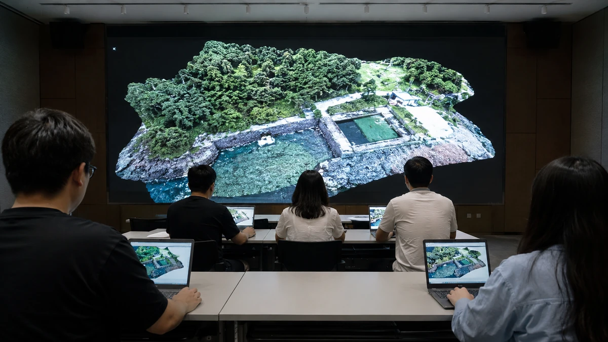
A new window into an old source of life
On South Korea’s southern resort island of Jeju, some of the most important places are not the dramatic cliffs, the black lava rock shorelines or the postcard-ready beaches that dominate travel brochures. They are springs — modest, sometimes easily overlooked places where groundwater rises naturally to the surface. For generations, those springs helped people survive on an island shaped by volcanoes, wind and porous stone. Now, local researchers are giving them a second life online.
The Jeju Research Institute’s Groundwater Research Center said this week that it has launched a digital map featuring three-dimensional models of 20 major spring sites across the island. The service allows users to rotate, zoom and move through the models from a dedicated section of the institute’s website, turning what might once have been a static archive into something closer to an interactive field visit.
That may sound, at first glance, like a niche technological update — another public database, another virtual exhibit. But in Jeju, it carries broader meaning. These springs, known in Korean as “yongcheonsu,” are not simply scenic spots. They are part of the island’s environmental memory and, historically, part of its survival system. By rendering them in 3D, local officials and researchers are not just preserving data. They are reframing how Jeju explains itself to the world.
For American readers, the closest comparison may be the way communities in the U.S. have tried to digitally document Indigenous heritage sites, national parks or disappearing wetlands before time, development or climate pressures alter them further. The point is not to replace the real place with a screen. It is to create a lasting, accessible record that helps people understand why the place matters in the first place.
In Jeju’s case, the project also speaks to a larger shift in tourism and public history. South Korea has spent years exporting culture through K-pop, television dramas and food, often with remarkable success. But beneath that global “Korean Wave,” or Hallyu, local governments and institutions are also working to introduce audiences to regional stories that do not always travel as easily: geology, folk traditions, village ecology and water systems that shaped everyday life. Jeju’s new 3D spring archive sits squarely in that effort.
Why springs matter on Jeju
To understand why the project is significant, it helps to understand Jeju itself. The island, located off the southern coast of the Korean Peninsula, is often described abroad as South Korea’s answer to Hawaii — a shorthand that captures its volcanic landscape and tourism appeal, if not all of its history. Jeju is famous for Hallasan, the volcano at its center, as well as crater cones, lava tubes and a rugged coastline. It is also known for a distinct local culture shaped by geographic separation from the mainland.
But unlike places blessed with large, visible rivers, Jeju has long had a more complicated relationship with water. Because the island is made largely of volcanic rock, rainwater often seeps underground rather than collecting on the surface. That geological reality made spring water especially valuable. Where groundwater emerged naturally, communities could build routines of washing, drinking, farming and daily survival around it.
That history is contained in the phrase often used to describe the springs: Jeju’s “water of life.” It is not merely poetic branding. It reflects a practical truth. Before modern infrastructure made piped water widely available, these spring sites were woven into the social and environmental fabric of the island. They were places where necessity and community met.
For readers outside Korea, this may be the most important cultural point. A spring on Jeju is not just a natural feature in the way a scenic overlook or coastal viewpoint might be. It can also be a memory site — a place where generations handled water, organized labor, built local habits and developed a particular awareness of what the island could and could not provide. In that sense, the springs tell a story not just about nature, but about adaptation.
That is part of what makes the new digital models more than technical assets. They invite viewers to consider the springs as historical infrastructure, not just as background scenery. On an island often marketed through beauty, the project shifts attention toward the deeper systems that made life possible there.
From a flat image to a lived landscape
The most notable feature of the new service is not simply that the spring sites are online. It is that they are interactive. Users can manipulate the models themselves, rotating them, enlarging them and moving across them rather than viewing a fixed photograph selected by someone else. That difference matters more than it may seem.
A flat image tells viewers where to look. A 3D model gives them some power to decide. That change, while technological, also changes the nature of the experience. It turns passive viewing into active exploration. Instead of being handed a single angle, users can examine shape, depth and spatial context on their own terms.
For foreign audiences unfamiliar with Jeju or Korean environmental heritage, that is especially useful. Travel writing and promotional material often flatten unfamiliar places into visual shorthand: a dramatic cliff, a popular café, a stone wall, a famous beach. Interactive modeling offers another kind of entry point. Even without deep background knowledge or fluency in Korean, a viewer can begin to grasp the physical character of a site by moving through it digitally.
That is one reason the project could resonate beyond Jeju. Around the world, cultural institutions have learned that digital access works best when it does more than display information. The strongest public-facing archives are often the ones that help users feel oriented inside a place, whether through 3D museum objects, virtual park tours or interactive historical maps. Jeju’s spring project reflects that same logic: if people can explore a site more intuitively, they may also understand its value more fully.
It is also a reminder that digital tools are no longer just the domain of entertainment giants or high-profile museums in capital cities. A regional environmental institution can now use the same broad language of immersion and user control to tell its own story. In practical terms, that means a local water heritage site can be presented with some of the same immediacy that online audiences have come to expect from major global attractions.
For Jeju, whose international image is often driven by tourism snapshots, that is a subtle but meaningful upgrade. The island is not only saying, “Look at this beautiful place.” It is saying, “Take time with this place. Learn how it is shaped. Understand why it mattered.”
Digital preservation, not digital replacement
The Jeju Research Institute has framed the project in part as a form of permanent digital preservation. That wording is important. Around the world, preservation increasingly means more than protecting a physical site from immediate damage. It also means creating durable records — detailed, shareable, searchable forms of documentation that can survive changes in weather, access and time.
In Jeju, where environmental identity is central to both local pride and the tourism economy, that kind of archive has obvious value. Natural heritage can feel permanent simply because it is natural. But that assumption is often misleading. Landscapes change. Water conditions shift. Human traffic grows. Public memory fades. A spring that once functioned at the center of community life can become visually familiar yet culturally obscure, especially to younger generations or visitors who encounter it without context.
A 3D archive does not solve all of those problems, but it addresses several at once. It creates a more precise record than a descriptive paragraph or a simple photo collection. It makes the site accessible even to those who cannot visit in person. And it gives educators, planners, residents and travelers a common reference point for discussing what the site is and why it deserves attention.
That distinction is worth emphasizing: digital preservation does not mean substituting the screen for the place. It means using digital tools to extend the life of the place in public understanding. The real spring remains irreplaceable. Its water, surrounding terrain, weather and local atmosphere cannot be fully translated into a model. But the model can help protect the spring’s significance by documenting it clearly and making it legible to more people.
American audiences have seen versions of this approach elsewhere. Historic neighborhoods threatened by redevelopment, Indigenous artifacts held in remote collections, coastal ecosystems vulnerable to erosion and Civil War landmarks under environmental strain have all been digitally mapped or scanned in the hope that better records will strengthen conservation and education. Jeju’s project belongs to that same family of efforts, though its subject is a distinctly Korean and local one.
In that sense, the map is both a tourism tool and a public archive. It sells curiosity, but it also stores memory. Those two functions are often treated as opposites, especially in heavily visited destinations. Jeju’s new service suggests they do not have to be.
A different kind of tourism pitch
Jeju is already one of South Korea’s best-known domestic travel destinations and an increasingly recognizable stop for international visitors. Yet much of its tourist image remains built around familiar categories: scenic drives, seaside hotels, café culture, volcanic views and Instagram-ready landscapes. That formula works, but it can also flatten the island into a visual product.
The new spring map points toward a more layered tourism model, one that invites visitors to read Jeju rather than merely consume it. Instead of treating the island as a checklist of attractions, the project encourages a slower form of attention — one focused on environmental systems, local history and the relationship between people and place.
For travelers from the U.S. or other English-speaking countries, that may make Jeju more compelling, not less. Many travelers now look for destinations that offer a stronger sense of story and specificity, not just beauty. They want to know what makes a place distinct, how local life evolved there and what lies beyond the famous photo spots. A digital map of spring sites may seem modest next to luxury resorts or blockbuster cultural festivals, but it serves exactly that appetite for depth.
It also broadens the idea of what counts as travel content. In the social media era, travel promotion often rewards speed — the quick stop, the instantly recognizable view, the image that signals arrival. Interactive heritage tools work in the opposite direction. They ask for more time. They reward curiosity. They suggest that a destination can be meaningful not just because it is beautiful, but because it reveals how beauty, survival and history are connected.
That message fits a broader global trend. Tourist boards from Scandinavia to New Zealand increasingly frame nature as something to be understood responsibly, not simply visited. Jeju’s 3D spring archive does something similar at a local scale. It introduces environmental assets as educational resources and cultural entry points, not just as anonymous scenery.
The accessibility of the service matters here, too. Because the models are available through the research center’s website, users can engage with them before a trip, after a trip or instead of a trip. A potential traveler can use the models to prepare. A former visitor can return to a site digitally and view it differently. A student or researcher with no travel plans at all can still learn something concrete about Jeju’s landscape.
In that way, the project also recognizes a reality that tourism officials everywhere now face: the first encounter with a place often happens online, long before a plane ticket is booked. If so, then digital interpretation is no longer secondary to tourism. It is part of tourism.
Explaining Jeju to the world
There is another reason the spring map matters: translation. Not translation in the narrow sense of converting Korean words into English, but translation in the broader journalistic sense of making one society legible to another.
Certain Korean cultural exports travel easily. Pop music, television competition formats, skin care products and hit streaming dramas come with built-in entertainment value and increasingly global audiences. But many local concepts do not. “Yongcheonsu,” the Korean term for these spring waters, is not a word likely to mean much to an American reader on first encounter. Without explanation, it risks sounding technical, obscure or overly specific.
The challenge for Korean institutions — and for journalists covering them — is to bridge that gap without stripping away local meaning. That is what makes the Jeju project notable. It presents the springs not as insider knowledge reserved for specialists, but as something the public can encounter directly. The 3D format helps lower barriers that language alone can create. Even if a user arrives with little context, the act of exploring the model provides an intuitive foothold.
For American audiences, it may help to think of these springs the way one might think about a historic covered bridge in New England, a Southwestern acequia system or a freshwater spring in Florida — not as interchangeable natural features, but as places that help explain how a community formed around local conditions. The spring itself is the artifact, but so is the relationship to it.
That is ultimately what Jeju is offering here: not just a set of digital objects, but a framework for understanding an island through water. Jeju is commonly introduced through geology — volcanoes, lava fields, rock formations. The spring archive adds another layer. It says that to understand the island fully, one must also consider the hidden movement of groundwater and the places where that hidden system became visible enough to sustain life.
This matters because global tourism often reduces places to the easiest symbols. The more famous a destination becomes, the greater the pressure to simplify it. Jeju’s new project resists that tendency. It expands the island’s public image rather than narrowing it. It suggests that modern tourism can make room for nuance if destinations are willing to present themselves that way.
What this says about Korea’s next cultural export
No one is likely to claim that a 3D archive of spring sites will become South Korea’s next global sensation on the scale of BTS or “Squid Game.” That is not the point. The significance of this project lies elsewhere: in showing how Korea’s local institutions are adapting the tools of the digital age to tell place-based stories that might otherwise remain invisible internationally.
There is a temptation, especially outside Asia, to treat South Korea’s global presence as almost entirely urban and pop-cultural — Seoul skyscrapers, hit dramas, beauty brands, high-speed internet and stadium concerts. All of that is real. But it can overshadow a parallel reality: South Korea is also a country of regional landscapes, local histories and environmental identities that do not fit neatly into the standard export package.
Jeju has long occupied a special place within that tension. It is one of the country’s most internationally legible destinations because it looks different from the Korean mainland and because its tourism appeal is immediately visible. Yet Jeju is also a place whose deeper significance is often hard to explain quickly. The island’s folk culture, its diving women known as “haenyeo,” its volcanic ecology and its water history all require more context than a slogan can provide.
That is why the spring archive feels timely. It uses modern digital language to communicate something old, local and environmentally grounded. In doing so, it offers a model for how heritage can be introduced to global audiences without being turned into pure spectacle. The tool is contemporary. The subject is deeply rooted. The connection between the two is where the innovation lies.
It also softens a debate that often frames tourism and conservation as competing interests. Jeju’s project suggests a third path: use technology to increase access and understanding while reducing the pressure to package every heritage site as a high-traffic attraction. If more people can engage with a place meaningfully online, the public value of that place does not depend entirely on physical foot traffic.
That may become increasingly important in destinations balancing fragile ecosystems with visitor demand. Across the world, from U.S. national parks to Mediterranean islands, tourism officials are grappling with how to protect natural assets while still sharing them. Jeju’s spring archive is small in scale compared with those global challenges, but it points in a promising direction.
In the end, the news out of Jeju is not about a flashy new gadget. It is about a shift in perspective. A place once central to everyday survival is being presented anew through digital tools, inviting a wider public to see it not as a relic or backdrop, but as part of a living environmental story. For Jeju, that is a meaningful act of preservation. For travelers and readers abroad, it is an invitation to look past the postcard image and into the systems, memories and resources that gave the island life.
And in an era when so much travel content is designed for speed, Jeju’s message is unexpectedly patient: Here is something old, essential and easy to miss. Take a closer look.
Comments
Post a Comment