South Korea treats monsoon season as a public safety test, not just a weather story
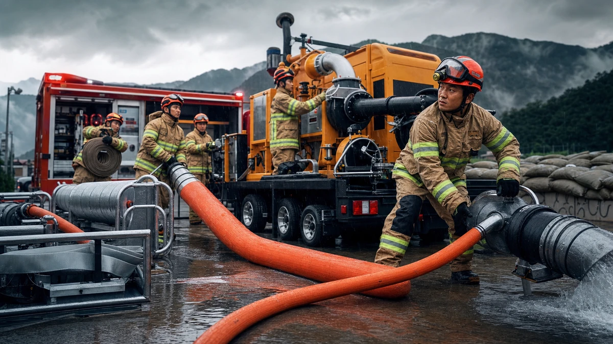
As heavy summer rain threatened parts of central and northeastern South Korea on Tuesday, national fire authorities made a move that says a great deal about how the country now thinks about extreme weather: They relocated specialized high-capacity flood-response equipment closer to areas considered most vulnerable to inundation.
The National Fire Agency said it forward-deployed a large-volume water discharge system from its Ulsan-based 119 Chemical Rescue Center to Chungju, a city in North Chungcheong Province that serves as an inland transportation hub. The goal was straightforward: shorten response times if flooding hits Gangwon Province, Gyeonggi Province and North Chungcheong Province, where intense rain can quickly swamp roads, low-lying neighborhoods and river-adjacent areas.
To an American reader, the decision may sound similar to pre-staging utility crews before a hurricane landfall, or moving National Guard high-water vehicles and pumps ahead of a major storm system. The storm itself may not yet have produced catastrophic damage, but emergency managers know that where equipment sits before the rain often matters as much as what happens after it starts.
That is especially true in South Korea during the summer monsoon period, known locally as jangma. The season typically brings concentrated downpours over a relatively short stretch of weeks, often colliding with another hallmark of Korean summers: punishing heat and humidity. In practical terms, that can mean one part of the country is under a heavy rain advisory while another is under a heat advisory, forcing local governments and residents to manage two kinds of weather danger at once.
The latest move by fire officials was not a dramatic rescue operation and did not come with confirmed reports of a large-scale disaster. But it offered a window into the less visible machinery that helps keep daily life functioning in a densely populated, highly urbanized country where weather can disrupt commuting, commerce, apartment living and regional travel in a matter of hours.
Why Chungju matters in a flood response plan
The choice of Chungju was not accidental. Located roughly in the middle of the country, Chungju connects parts of the central inland region with Gangwon to the northeast and the broader Seoul metropolitan orbit to the northwest. In emergency planning terms, it is a useful launch point.
South Korean authorities appear to have judged that keeping the equipment in Ulsan, an industrial city in the southeast, would leave too much distance between the asset and the places most likely to need fast flood intervention. By shifting it to Chungju in advance, officials positioned it closer to the probable risk zone rather than waiting until floodwaters had already begun rising.
That kind of forward deployment can be decisive in flood events. A difference of even a few hours may affect whether an underpass stays open, whether a flooded basement can be pumped out before damage worsens, or whether emergency workers can secure access routes to neighborhoods near rivers and streams. In countries prone to flash flooding, response time is often measured not only in lives saved but also in how quickly a city can restore some sense of normalcy.
For Americans who may think first of coastal storms when they hear the word “flooding,” South Korea presents a somewhat different picture. Much of the danger comes not from storm surge but from intense bursts of rainfall over mountains, valleys and urban basins. Water runs quickly downhill, drainage systems can be overwhelmed and paved city landscapes leave little room for absorption. That combination makes inland flooding a recurring concern, even away from the coast.
Chungju’s importance also reflects how South Korea organizes national and local response. The country’s central authorities can move specialized resources across provincial lines, but effective disaster management still depends on having those resources close enough to support city and provincial fire units when conditions deteriorate. In that sense, the equipment transfer was a logistical decision with clear strategic value.
What the equipment actually does — and why it matters
The machine at the center of this response is referred to in Korean as a “large-capacity foam discharge system,” a name that can sound confusing outside its original context. Despite the technical label, the key point is that it is a high-volume system designed to move or discharge large quantities of water quickly in emergency conditions. In flood response, that means pumping water out of inundated spaces or handling large-scale water management tasks that ordinary local equipment may struggle to address fast enough.
South Korean officials also said a separate system capable of handling 30,000 liters per minute was assigned to respond to flooding incidents in Daejeon, Sejong, South Chungcheong Province and North Jeolla Province from the Seosan 119 Chemical Rescue Center. The number by itself does not tell the whole story of expected damage, but it does offer a sense of scale. This is not a standard neighborhood fire engine being repositioned. It is heavy specialized equipment meant for high-demand situations.
That distinction matters because South Korea’s emergency system includes national-level rescue assets designed for scenarios that exceed what a single local jurisdiction can comfortably manage. The Central 119 Rescue Headquarters, which oversees such capabilities, handles large disasters and specialized rescue missions. When conditions threaten to outrun local capacity, national assets can reinforce regional responders.
American audiences might compare that setup to the way FEMA resources, urban search-and-rescue teams or state-level emergency management assets can backstop local fire departments during major storms. The local crews remain essential, but they are not left to absorb every large-scale emergency on their own.
In South Korea, the “119” designation serves a role similar to “911” in the United States, though it is specifically tied to fire and rescue response. So when officials refer to entities such as the Chungcheong-Gangwon 119 Special Rescue Unit or the Ulsan 119 Chemical Rescue Center, they are talking about components of a professional emergency response network that includes specialized teams, equipment and interregional coordination.
The equipment move, then, was about more than relocating machinery. It was an attempt to place national capability at the edge of probable need — close enough to matter, but organized enough to serve multiple jurisdictions if the rain intensified.
A split regional strategy shows how South Korea is managing weather risk
One of the more revealing details in the government’s announcement was that officials did not rely on a single asset to cover a broad swath of the country. Instead, they effectively divided central South Korea into response zones.
The forward-deployed system in Chungju was designated for possible flood incidents in Gangwon, Gyeonggi and North Chungcheong. Meanwhile, the Seosan-based unit was assigned to cover Daejeon, Sejong, South Chungcheong and North Jeolla. That kind of regional split may sound bureaucratic, but it reflects a modern emergency management principle: mobility is important, but overconcentration can become a liability.
In plain terms, officials appear to be avoiding a scenario in which one piece of specialized equipment is expected to serve too many places at once. By drawing a line between inland-central areas and the west-central to southwestern corridor, they are trying to preserve flexibility while reducing travel time. For a country as geographically compact as South Korea, that may seem unnecessary at first glance. But in a flooding emergency, road access, congestion and terrain can make short distances deceptively difficult.
The affected regions also have different kinds of exposure. Gyeonggi surrounds Seoul and includes heavily populated suburban and industrial areas tied closely to the capital region. Gangwon includes mountainous terrain where runoff and localized flooding can create fast-moving hazards. North and South Chungcheong sit in the country’s interior and include transport corridors, smaller cities and river-linked communities. Sejong, a planned administrative city that houses many government functions, adds another layer of importance. North Jeolla includes inland and western areas where heavy rain can affect agriculture, roads and urban districts alike.
Seen from Washington, New York or Los Angeles, the terminology of Korean provinces can feel distant. But the underlying governance challenge is familiar: how do you pre-position enough equipment to help a wide range of communities without leaving one side of the map exposed while you protect the other? The South Korean approach here suggests a system increasingly built around preemption, regional specialization and speed.
The weather itself tells a larger story about Korean summers
The equipment move took place against a backdrop that will sound increasingly familiar to anyone following climate-related weather volatility around the world. On the same day, South Korea’s weather agency said it would lift a heavy rain advisory for Sangju in North Gyeongsang Province at 8 p.m., while keeping the advisory in place for nearby Mungyeong. Parts of North Gyeongsang were also under a heat advisory.
That juxtaposition — heavy rain in one place, dangerous heat in another — captures the uneasy rhythm of a Korean summer. Jangma is often discussed outside Korea simply as “monsoon season,” but for residents it is less a singular event than a period of constantly shifting local stress. An office worker may leave home carrying an umbrella in the morning and still face stifling heat later in the day. A market vendor may worry at once about customer traffic, spoiled goods, drainage and heat exhaustion. Travelers heading from Seoul to a provincial city can move from clear skies into sheets of rain in a matter of hours.
For foreign visitors drawn by K-pop, Korean food, beauty brands or the country’s fast-paced city life, that infrastructure backdrop is easy to miss. The polished experience of modern Seoul — the reliable transit, busy shopping districts, packed festivals and crowded commuter arteries — depends heavily on systems designed to keep the urban machine running when weather turns hostile.
South Korea’s rainy season can also feel more compressed than what many Americans are used to. Instead of a months-long pattern of occasional summer thunderstorms, the country often experiences highly concentrated episodes of downpour capable of overwhelming daily routines quickly. In recent years, deadly flooding in parts of the country has reinforced public awareness that “just rain” can become a severe civic hazard.
That helps explain why weather advisories are closely watched and why a government meeting on rainfall preparedness can carry real weight. In South Korea, monsoon coverage is not merely about whether people should carry an umbrella. It is about whether apartment complexes, underground spaces, roads, streamside trails and commercial districts can remain safe and functional.
Behind the scenes, a fast-moving bureaucracy is part of the story
The National Fire Agency said Acting Commissioner Choi Yong-cheol presided over a situation assessment meeting Tuesday afternoon to review weather conditions, the response status of city and provincial authorities, and whether damage had already occurred. That detail may sound procedural, but it points to a critical aspect of South Korean governance: disaster response often depends on the speed of administrative coordination as much as on the bravery of responders in the field.
In these assessment meetings, officials gather meteorological data, local readiness reports and incident updates in one place so they can adjust posture before separate pieces of the system begin working at cross-purposes. If one province is seeing deteriorating conditions while another has equipment to spare, or if rain bands are shifting unexpectedly, those decisions need to be made quickly and with a shared operating picture.
South Korea’s system blends centralized coordination with local execution. National agencies can move specialized assets and frame the broader response, while city and provincial fire headquarters handle on-the-ground deployment, local rescues and resident safety measures. That structure is neither wholly centralized nor purely local. It is designed to let national resources reinforce regional authorities without replacing them.
For American readers, it may be useful to think of this as a hybrid between federal coordination and county-level emergency action. The central government sets posture and mobilizes uncommon assets, but local responders still do the close-up work of barricading flooded roads, checking vulnerable neighborhoods and responding to calls for help.
The administrative speed on display here also reflects lessons learned. South Korea, like many countries, has faced criticism after past disasters over whether warnings, coordination and interagency communication moved fast enough. Against that backdrop, forward deployment and assessment meetings are not just routine paperwork. They are part of a broader effort to show that preparation is now an operational priority, not an afterthought.
An unglamorous story that explains how modern Korea functions
This is not the kind of Korea story that typically travels internationally. It does not involve a blockbuster TV drama, a viral music act or a technology product launch. There are no celebrity names attached to it, no cultural exports to package neatly for global audiences and no obvious spectacle.
But in some ways, that is precisely why it matters. The global fascination with South Korea often centers on what the country produces — entertainment, cosmetics, design, food, electronics and digital culture. Far less attention is paid to the public systems that make ordinary life in those cities and regions resilient enough to absorb repeated stress.
Flood-response equipment positioned in advance of a storm does not make for glamorous imagery. Yet it is part of the same story as the crowded subway station reopening after a downpour, the street market resuming trade, the highway remaining passable or the apartment district recovering quickly from inundation. The visible dynamism of Korean urban life rests on invisible preparations like these.
The facts confirmed by authorities were limited and should be treated with care. Officials said the Ulsan-based large-capacity system had been moved to Chungju to prepare for flooding risks in Gangwon, Gyeonggi and North Chungcheong. They said the Seosan-based 30,000-liter-per-minute system would cover Daejeon, Sejong, South Chungcheong and North Jeolla. They also said an internal assessment meeting reviewed weather conditions, regional readiness and any reported damage.
What officials did not establish in the information released was the scale of any current disaster, the amount of rain still expected, or whether additional deployments might follow. That distinction matters. The clearest interpretation is not that a major catastrophe had already unfolded, but that South Korea’s emergency apparatus was trying to get ahead of a foreseeable risk.
And that may be the larger lesson for international readers. In an era of increasingly volatile weather, resilience is often measured not by dramatic rescues alone but by smaller acts of preparation: moving the pumps before the streets fill, dividing response zones before communications snarl, convening decision-makers before the first emergency call spikes.
South Korea’s latest monsoon-season move fits that pattern. It is a reminder that the systems sustaining everyday life — whether in Seoul’s orbit, the central inland corridor or mountain-linked provincial communities — depend on decisions made long before most people notice. When the rain comes, that invisible head start can be everything.
Comments
Post a Comment