
A Region Bigger Than Its Borders
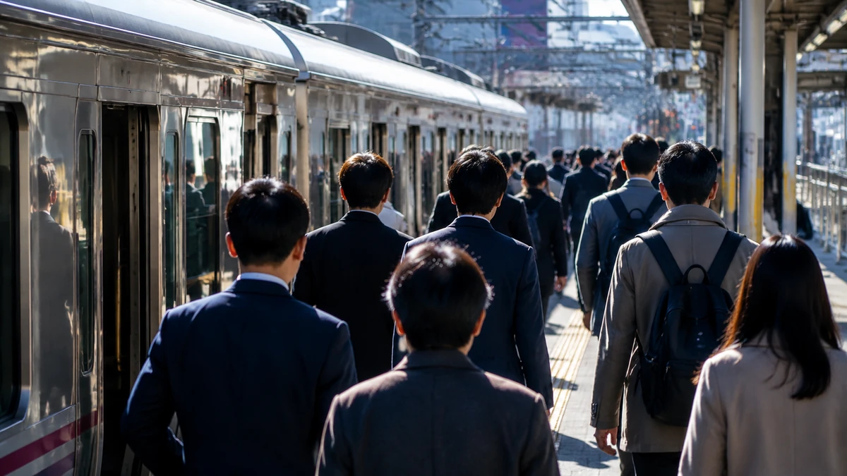
For many Americans, the idea will sound familiar even from half a world away: people may sleep in one city, work in another, shop in a third and rely on hospitals, schools and transit systems that do not neatly match the official lines on a government map. It is the everyday reality of greater New York, the Washington region and Southern California. New data from South Korea suggests something similar is becoming more pronounced in one of the country’s most important industrial corridors.
In the southeastern part of South Korea, the neighboring jurisdictions of Busan, Ulsan and South Gyeongsang province — often grouped together in Korean shorthand as “Bu-Ul-Gyeong” — are increasingly operating as a single shared living and labor zone. According to a 2025 regional social survey released by the Dongnam Regional Statistics Office and reported by Yonhap News Agency, a growing share of residents in the region commute across city or provincial boundaries for work, even though the total number of commuters has dipped slightly since 2023.
That may sound like a technical statistical finding. It is not. Commuting patterns are among the clearest ways to understand how a society actually functions. They show where jobs are, where housing is affordable, how transit connects daily life and whether official administrative boundaries still reflect how people live. In this case, the data points to a simple but consequential reality: in South Korea’s southeast, the lines separating Busan, Ulsan and South Gyeongsang matter less and less in the routines of ordinary workers.
The finding also offers an important counterpoint to the way many outside observers think about South Korea. International coverage often focuses on Seoul, the capital region and the country’s deep economic centralization. That concentration is real. But beyond the Seoul metro area, southeastern Korea remains one of the nation’s most significant industrial belts, home to ports, factories, shipyards, petrochemical complexes and automotive production. What the new numbers show is that this regional economy is not just linked on paper or through policy slogans. It is linked by millions of repeated daily trips.
For American readers, one useful comparison might be the area connecting Baltimore, Washington and Northern Virginia, or the way residents in New Jersey, New York City and Connecticut move through an interdependent economy despite living in different jurisdictions. South Korea’s southeastern corridor is not identical, of course. Its urban density, geography and industrial mix are different. But the underlying idea is familiar: where people live and where they work are no longer contained by the boundaries local governments inherited.
What the Numbers Show
The headline figures are striking. Among the 6.78 million people age 15 and older living in Busan, Ulsan and South Gyeongsang in 2025, about 3.78 million were commuters, according to the statistics office. That means 55.8% of the population in that age group regularly traveled for work. In other words, well over half of the region’s residents were part of a routine labor movement that helps bind the three jurisdictions together.
What makes the findings more interesting is that the number of commuters fell by about 16,000 compared with 2023, while the commuting rate still edged up by 0.2 percentage points. At first glance, those figures may seem contradictory. But together they suggest that the region’s labor and residential patterns cannot be explained by simple population decline alone. Even if the raw number of commuters slipped, commuting remained deeply embedded in everyday life and became slightly more prominent as a share of the relevant population.
That distinction matters. Absolute numbers tell one story about scale. Percentages tell another story about structure. A region can lose people overall while becoming more tightly connected in practical terms. That appears to be what officials are seeing in southeastern South Korea: not necessarily a dramatic surge in people, but a stronger pattern of cross-border movement within the existing urban-industrial zone.
The data itself does not assign a single cause, and responsible reporting should not overstate what the survey proves. The report, as summarized publicly, does not break down every underlying driver, such as detailed industry changes, housing costs or specific transportation upgrades. Still, some implications are difficult to ignore. When more people’s daily routines extend beyond the jurisdiction where they officially live, it usually means employment opportunities, residential choices and transit networks are interacting across a wider regional footprint.
In plain terms, this is what metropolitan integration looks like before politicians fully catch up to it. A city border remains on the map. But in lived experience, the region behaves more like a connected whole.
Why Commuting Matters So Much in South Korea
Commuting is not just about traffic or train schedules. It is one of the best barometers of how a modern economy is organized. A worker’s daily route is shaped by wages, rent or home prices, school access, family caregiving needs, public transportation, job concentration and industrial geography. If large numbers of people cross local borders every day, that is usually evidence of a deeper regional interdependence.
That is especially true in South Korea, where administrative units can be precise and important in government planning, but daily life often spills beyond them. Busan is a major port city and South Korea’s second-largest city. Ulsan is one of the country’s industrial powerhouses, known globally for shipbuilding, automobiles and petrochemicals. South Gyeongsang province surrounds and connects many smaller and mid-sized cities, manufacturing districts and residential communities tied to both. On paper, they are separate local governments. In practice, they form an economic system.
For readers less familiar with Korean regional structure, it helps to know that South Korea’s local divisions include metropolitan cities and provinces. Busan and Ulsan are metropolitan cities with administrative status roughly comparable to major self-governing urban jurisdictions. South Gyeongsang is a broader provincial unit containing multiple cities and counties. Yet workers do not organize their lives around those labels. They organize around opportunities, commute times and family needs.
That is why the survey carries significance beyond a set of dry demographic tables. It tells us that the “life sphere” — a term commonly used in Korean discussions of regional planning to describe the practical zone in which people live their daily lives — is expanding beyond formal city and provincial boundaries. In American terms, it is the difference between a legal boundary and a commuter shed. One is a matter of governance. The other is a matter of reality.
The distinction matters for policy because public systems often lag behind social behavior. If workers cross boundaries every day but transportation planning, childcare access, health care coordination and public investment remain segmented by local bureaucracy, friction builds. Longer travel times, more transfer points, higher commuting costs and uneven service access can all follow. So can political disagreements over who should pay for infrastructure that benefits a region larger than any one city.
South Korea has long wrestled with how to balance national growth, the dominance of the Seoul metropolitan area and the vitality of other regions. In that larger debate, the Bu-Ul-Gyeong numbers matter because they show southeastern Korea is not just a cluster of adjacent jurisdictions. It is behaving more like a shared labor market.
The Routes That Reveal a Shared Economy
The survey also offers a more granular picture of how that integration works. The most common origins of commuters heading into Ulsan were Yangsan in South Gyeongsang, Gijang in Busan and Haeundae, another district in Busan. Those flows reinforce Ulsan’s role as a major employment hub while also showing how closely linked it is to surrounding residential areas.
Americans might think of a large employment center drawing workers from suburban and neighboring counties across state lines. The pattern is common around big hospitals, defense contractors, logistics hubs or industrial zones in the United States. In Ulsan’s case, the pull likely reflects its concentrated industrial base and high-value employers, even if the survey summary does not assign causation by sector.
The movement is not one-way. The survey found that the top destinations for commuters leaving Ulsan were Gyeongju in North Gyeongsang province, Yangsan in South Gyeongsang and Gijang in Busan. That is significant because it suggests Ulsan is not merely a job magnet drawing in labor from a passive periphery. It is also part of a reciprocal regional web, sending workers outward to neighboring areas. This is often how mature metro economies function: multiple nodes, multiple directions, overlapping patterns.
South Gyeongsang’s commuting ties tell a similar story. The largest sources of inbound commuters into South Gyeongsang were Busan’s Buk, Geumjeong and Dongnae districts. Meanwhile, the largest destinations for commuters leaving South Gyeongsang were Busan’s Gangseo and Sasang districts, along with Ulju in Ulsan. Rather than showing a single dominant center swallowing the rest, the list points to dense cross-border activity along several edges of the region.
That may be the most telling feature of all. The story is not only about major cities pulling workers inward. It is about border areas becoming functionally porous. Districts and municipalities that sit near one another, even under different local governments, are increasingly stitched together by routine movement. Over time, that can alter everything from retail patterns to school demand to real estate markets.
For Americans, it may help to imagine if the most revealing map of a region were not political but kinetic: not who governs what, but where people are actually moving every morning and evening. That is effectively what this survey provides. And the picture it paints is of a southeastern Korean region with increasingly blurred practical boundaries.
More Than a Transportation Story
It would be easy to read these numbers as a transit story alone, but that would be too narrow. Commuting flows reflect much broader choices and constraints. A worker might live in one jurisdiction because housing is cheaper there, because parents or in-laws can help with childcare there, or because schools seem more attractive. Another may work across the border because that is where the factory, office or logistics site is located. Others may move residences without changing jobs, widening the commute in exchange for different living conditions.
In South Korea, where population aging, low birthrates and regional demographic decline are major national concerns, that complexity becomes even more important. A smaller or older population does not necessarily mean less regional integration. It can sometimes mean the opposite: households become more strategic, jobs cluster in specific corridors and workers travel farther or across more boundaries to match employment with family life.
The survey’s finding that the commuter count dipped slightly while the commuting share rose is consistent with that kind of restructuring. It hints at a labor market and residential geography that may be getting more selective, more specialized or more consolidated in certain areas. Again, the publicly summarized data does not prove exactly which mechanism is driving the shift. But it clearly shows that daily cross-boundary mobility remains central to the region’s social and economic life.
This is why commuting statistics are often more revealing than grand political rhetoric. Governments can announce regional cooperation, economic corridors or balanced development plans. But if people still mostly live and work within isolated local units, those initiatives may remain aspirational. When the commuting data moves, it is harder to dismiss. It means people themselves have already begun to act as though the region is integrated.
There is also a human dimension that the percentages can obscure. Cross-border commuting usually comes with time costs, money costs and stress. The Korean article summary did not include average commute times or transit expenses, so it would be wrong to generalize too specifically. But any increase in border-crossing work travel raises familiar questions: Are roads and rail lines keeping up? Are transfers easy? Do workers bear excessive burdens because jobs and homes are mismatched? And are public services designed around where people are registered to live, or where they actually spend their days?
Those are not abstract questions. They shape quality of life. They also shape a region’s competitiveness. A labor market works best when workers can reach jobs efficiently and employers can draw from a broad talent pool without crushing commute burdens. In that sense, a commuter map is also an economic performance map.
What It Means for Policy and Daily Life
If Busan, Ulsan and South Gyeongsang increasingly function as one living zone, the policy implications are difficult to avoid. Transportation planning may need to be more regional. That could mean better coordination of rail, bus and fare systems across jurisdictions, more attention to transfer hubs and greater focus on the border districts where daily flows are thickest. A worker does not care much which local government is nominally in charge when a missed connection adds 40 minutes to the trip home.
Housing policy is also part of the story. When people live in one jurisdiction and work in another, it often reflects some combination of affordability, availability and lifestyle preferences. If the jobs are concentrated in industrial or urban centers while housing growth spreads into nearby districts, cross-border commuting becomes a structural feature, not a temporary anomaly. Policymakers then face a choice: accommodate the pattern with better infrastructure or try to reshape it through land use and development.
Public services can no longer be viewed as neatly local, either. Childcare, eldercare, medical access and even consumer behavior follow mobility patterns. If a resident lives in one place but spends most waking hours elsewhere, the division between “resident population” and “daytime population” grows more important. American metro areas have long dealt with this dynamic, with downtown workers, suburban households and regional transit systems pushing against older administrative formulas. South Korea’s southeast appears to be encountering a similar challenge in its own way.
The issue also touches politics. Local governments may compete for investment, prestige and tax base, but their residents are already sharing one another’s labor markets. That can create tension as well as opportunity. Cooperation is easier to praise than to finance. Who pays for major regional transit links? Who benefits most from industrial growth? Which locality shoulders environmental or congestion costs while another gains economic returns? These are classic metropolitan questions, and southeastern South Korea is increasingly asking them too.
Yet there is also a strong argument for optimism. A region that is interconnected by daily life can be more resilient than one fragmented into isolated local economies. Workers gain a broader range of job options. Employers can recruit from a wider area. Families can weigh tradeoffs among housing, schools and caregiving without being locked inside one jurisdiction’s boundaries. If the infrastructure and policy architecture evolve to support that reality, regional integration can be a strength.
That may be especially important outside the Seoul area. South Korea’s national conversation often centers on the gravitational pull of the capital region. But the Bu-Ul-Gyeong data suggests another model of regional vitality: not a single dominant city standing alone, but a network of adjoining cities and districts functioning together as a larger whole.
A Window Into South Korea Beyond Seoul
For global readers, this story matters partly because it broadens the picture of South Korea. The country is often portrayed through the lenses of K-pop, technology giants, political tensions with North Korea and the overwhelming dominance of greater Seoul. All of those are important. But they can overshadow the complexity of regional life in other parts of the country.
The southeastern corridor anchored by Busan and Ulsan is one of South Korea’s most consequential noncapital regions. Busan is a major gateway for maritime trade and culture. Ulsan has long been synonymous with heavy industry. South Gyeongsang links urban and industrial communities across a broader provincial landscape. Together they form one of the country’s key production and logistics zones.
What the commuting data shows is that this is not simply a cluster of places located near one another. It is a lived region. A person may sleep in Yangsan, work in Ulsan, shop in Busan and have relatives in yet another district nearby. Multiply that by millions and the result is a practical metropolitan system whose boundaries are drawn by movement rather than law.
That is an important concept for outsiders to understand. In South Korea, as in the United States, the map people use to describe a region is not always the map they live by. Official jurisdictions remain powerful in budgeting, elections and administration. But the geography of daily life can outrun those structures. When that happens, statistics about commuting become a kind of social X-ray, revealing the skeleton of a region underneath its formal labels.
The latest survey does not answer every question. It does not fully explain why the commuting rate rose, how much each sector contributed or how future infrastructure plans may alter the picture. It leaves room for further reporting, especially on travel times, costs and the lived experiences of workers making these trips every day. But within the limits of the data, one conclusion stands out clearly: southeastern South Korea is becoming more integrated across administrative lines, and that integration is visible in the most ordinary act of all — going to work.
There is something fitting about that. The most meaningful social changes are not always announced with fanfare. Sometimes they show up in the quiet accumulation of routine decisions: where to live, where to work, which road to take, which train to catch before sunrise. In Busan, Ulsan and South Gyeongsang, those decisions are binding separate jurisdictions into something closer to a common metropolitan life. The map still shows three distinct local governments. The commute increasingly tells a different story.


0 Comments