Satellite Images Suggest Informal China-North Korea Border Cargo Traffic Has Resumed Along the Yalu River
A quiet stretch of river is drawing new scrutiny
Fresh satellite imagery is offering a new, if still incomplete, window into one of the world’s most opaque border zones: the frontier between China and North Korea along the Yalu River. Analysts say images taken in recent weeks show signs that cargo activity has resumed at a series of informal crossing points after months of relative quiet, raising new questions about sanctions enforcement, North Korea’s supply lines and the state of Beijing’s relationship with Pyongyang.
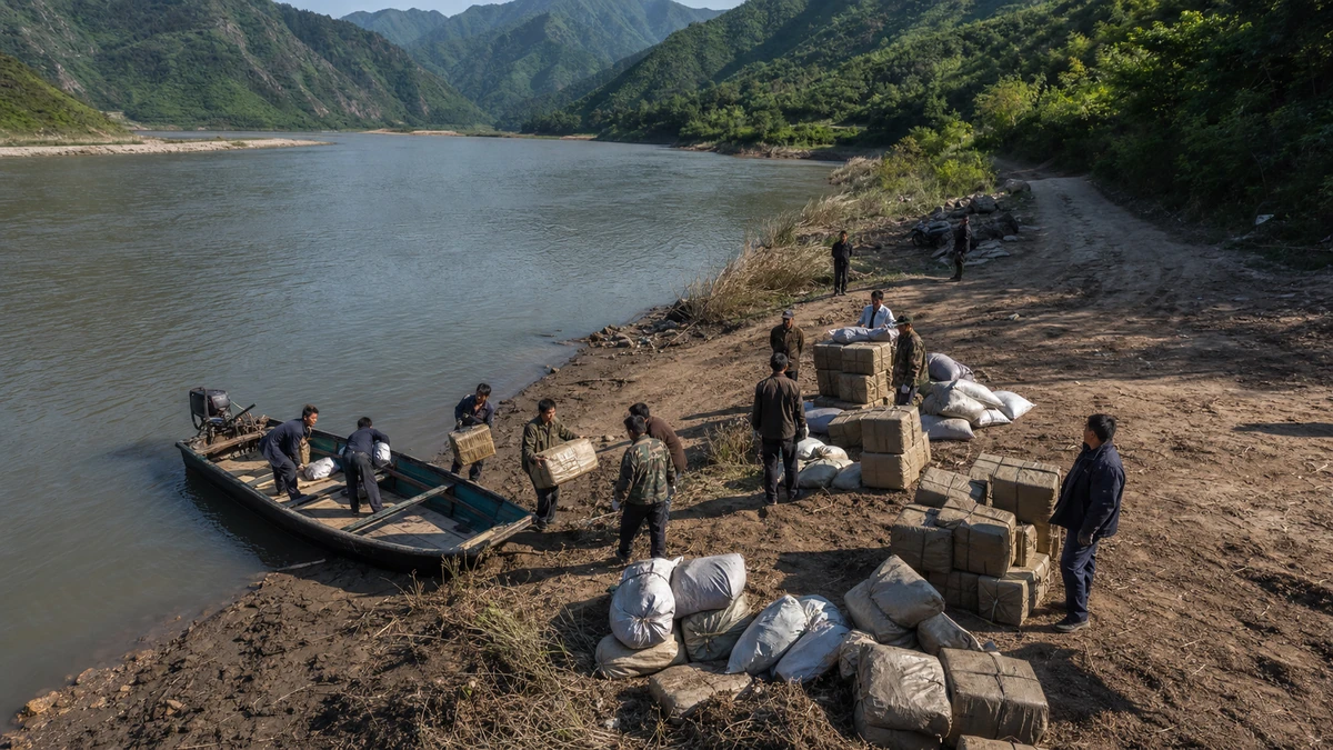
The findings, first reported by NK News and based on commercial satellite images from the U.S. firm Planet Labs, point to activity at 13 unofficial cargo routes in North Korea’s Yanggang province, a rugged northern region that faces China across the river. Since June 19, according to the report, goods or cargo-like objects were visible at 10 North Korean-side staging areas, suggesting that materials may have been brought in from China and then moved onward into the country’s interior.
That may sound like a narrow technical development, but on the Korean Peninsula, even small movements at the border can carry outsized significance. North Korea does not provide transparent trade data in the way most countries do, and access to the country remains tightly restricted for foreign journalists, aid workers and independent inspectors. That means analysts often rely on satellite imagery, shipping data and fragmentary official statements to piece together what is happening inside the state.
In that environment, stacks of cargo seen from space can become a meaningful clue. They do not prove exactly what was moved, who ordered it or whether the traffic violated specific sanctions rules. But they can indicate that networks outside formal customs channels are active again — and that matters far beyond the riverbank itself.
For American readers, the closest comparison may be how U.S. analysts track developments in closed or hostile states using overhead imagery: parking lots filling up at missile sites, railcars appearing near military depots, ships changing routes or trucks gathering near border crossings. In North Korea’s case, where official disclosures are rare and often propagandistic, the river border with China functions as one of the few visible pressure points where economics, diplomacy and security all meet.
What the satellite images appear to show
According to the reporting, the imagery identified activity at 13 smuggling or informal cargo routes in three North Korean counties — Samsu, Kim Jong Suk and Kim Hyong Jik — all in Yanggang province. These are not the names most Americans would immediately recognize, unlike Pyongyang or the Demilitarized Zone. But geographically, they matter because they sit along a stretch of frontier where the natural landscape can enable unofficial movement separate from heavily monitored formal crossings.
The Yalu River, known in Korean as the Amnok, forms much of the border between North Korea and China. For many Americans, the best-known section is farther south near the Chinese city of Dandong and the North Korean city of Sinuiju, an area often shown in news footage because it is one of the most visible gateways into North Korea. But the frontier extends far beyond those better-known urban points. In more remote areas, especially where terrain is mountainous and state oversight can be uneven, the border has long been associated with informal trade, smuggling and survival-oriented commerce.
In this case, analysts reportedly observed cargo accumulating at North Korean-side collection points and then disappearing days later, a pattern consistent with delivery and redistribution. That does not amount to direct proof of a cross-border transaction. Satellite images can show objects, movement and patterns over time, but they cannot by themselves identify the contents of boxes or confirm the identities of the people involved. Even so, repeated activity across multiple sites suggests something more than a one-off anomaly.
The wording here matters. The evidence supports the idea that cargo movement appears to have resumed. It does not establish beyond doubt what goods were moved, how much was transferred or whether Chinese authorities were aware of every instance. In North Korea coverage, that distinction is essential. Analysts and journalists who follow the country closely are often forced to work in probabilities rather than certainties, especially when dealing with satellite imagery and closed-border behavior.
Still, patterns have meaning. When 10 staging areas show visible goods over a relatively short period and 13 routes display signs of activity, specialists take notice. The significance lies less in any single pile of cargo than in the broader suggestion that a dormant or slower-moving border network may be operating again.
Why unofficial trade matters under sanctions
To understand why this is important, it helps to step back and look at North Korea’s place in the global economy. The country is subject to extensive United Nations and U.S. sanctions over its nuclear weapons and ballistic missile programs. Those measures are designed to restrict the North’s access to materials, foreign currency and trade channels that could support its weapons development or elite-controlled economy.
But sanctions regimes are only as strong as their enforcement, and North Korea has spent decades developing ways to work around them. That has included ship-to-ship transfers at sea, opaque corporate networks, labor exports, cyber theft and, according to years of reporting and expert analysis, informal border commerce with China. Not every cross-border shipment is necessarily illicit under every legal framework; the point is that unofficial channels are especially hard to monitor, regulate or document.
For Washington and its allies, this matters because the North Korean economy is not sealed in the way its propaganda sometimes suggests. It survives through a mix of state control, limited tolerated markets and external lifelines. China is by far North Korea’s most important economic partner, even when bilateral ties appear strained. If goods are again moving through informal routes along the Yalu, it could mean local traders, security networks or state-connected actors have found more room to operate.
That does not automatically mean a major sanctions collapse is underway. The apparent activity may be small-scale, episodic or focused on basic commodities rather than strategically sensitive goods. The cargo could include food, consumer products, industrial inputs or other items difficult to identify from space. But even seemingly mundane goods can be politically meaningful in North Korea, where access to everyday supplies can affect local markets, livelihoods and the regime’s ability to manage economic pressure.
For an American audience, one useful comparison is the role back-channel commerce can play in sanctioned economies elsewhere. Even when formal trade shrinks, informal networks often become more valuable, not less. They can keep local economies functioning, enrich intermediaries, blunt international pressure and signal which neighboring states are willing to tolerate gray-zone activity. That is why specialists watch these routes so closely.
The China factor is impossible to ignore
No story about North Korea’s border economy can be separated from China. Beijing is North Korea’s largest trading partner, political buffer and, at times, reluctant benefactor. China has supported U.N. sanctions on paper while also resisting the kind of destabilizing pressure that could trigger regime collapse, refugee flows or a strategic realignment on its border. In practice, that has long produced a balancing act: pressure Pyongyang enough to show displeasure, but not so much that the system breaks.
The new imagery has drawn extra attention because the timing overlaps with a broader warming in regional diplomatic atmospherics. Reporting on the border movement notes that the renewed activity became visible after a high-profile period of diplomacy involving China and North Korea. That does not prove cause and effect. It would be irresponsible to say a visit or summit directly triggered border cargo flows without much stronger evidence. But timing often shapes analysis, especially in a place where open information is scarce.
In Northeast Asia, symbolism matters. A leadership visit, a summit photograph, a state media phrase or a border checkpoint reopening can all be read as signals of shifting priorities. If informal cargo traffic is indeed picking up after a period of quiet, analysts will naturally ask whether local enforcement loosened, whether bilateral coordination improved or whether economic necessity simply pushed traders back into old habits.
China’s own interests are also practical. Stability along the border matters to Beijing. A complete breakdown in North Korea would create risks China does not want: humanitarian spillover, military uncertainty and the possibility of a U.S.-allied Korea on its doorstep. At the same time, China has little interest in advertising any tolerance for sanction-evading trade. That ambiguity is part of what makes satellite evidence so important. The images can reveal behavior even when governments say little or nothing.
American readers may recall similar debates over how to interpret Chinese enforcement of sanctions at sea or along land routes. The issue is rarely black and white. Central government policy, local government incentives, border-security practices and illicit profit motives can all coexist. What looks like a geopolitical signal from Washington may, on the ground, also reflect local actors exploiting gaps in oversight.
Why satellite imagery has become indispensable in North Korea reporting
The story also highlights a broader transformation in how journalists and researchers cover closed states. A generation ago, much of what the outside world knew about North Korean internal activity came from defectors, intelligence leaks, state media monitoring and occasional diplomatic reporting. Those sources remain important, but commercial satellite imagery has changed the field dramatically.
Today, relatively frequent images from private companies allow news outlets, think tanks and academic researchers to monitor infrastructure, transportation, agriculture, prisons, military facilities and border activity with a degree of consistency that was once limited mostly to governments. That does not make analysis easy. Interpreting imagery requires caution, technical skill and humility about what cannot be known. Shadows can mislead. Weather can obscure. A stack of material is still just a visible object unless corroborated by other information.
Even so, in the North Korean context, open-source satellite analysis has become one of the most credible tools available for identifying change over time. It is particularly valuable when the question is not “Can we prove every detail?” but rather “Has something measurably changed on the ground?” In this case, the answer appears to be yes: sites that had been quiet since late last year now show renewed signs of activity.
This kind of reporting also serves a democratic function. It gives the public, policymakers and international observers a shared evidentiary basis for discussing developments that might otherwise remain hidden behind official secrecy. Americans are accustomed to seeing satellite images used in war coverage, disaster response and environmental reporting. In Northeast Asia, they are now central to understanding sanctions, border management and the day-to-day mechanics of life around one of the most tightly controlled states in the world.
That does not eliminate uncertainty. It simply narrows it. We may not know what every package contains, but we can still see whether cargo is appearing, disappearing and moving in patterns consistent with organized transport. In a place like North Korea, that alone can be news.
What this could mean for North Korea’s internal economy
Although the report focuses on border observations, the implications could extend deeper into North Korea’s domestic system. One notable detail is that the cargo did not appear to remain at the riverbank. Analysts said some goods seemed to be moved onward into the country after arriving at staging points. If accurate, that suggests a functioning delivery chain rather than mere accumulation at the frontier.
That matters because North Korea’s internal logistics network is often under strain. The country faces chronic shortages, poor infrastructure and a command economy that has never fully extinguished the role of informal market activity. Since the famine of the 1990s, many North Koreans have relied on semi-tolerated markets, known as jangmadang, to obtain food and household necessities. Those markets are not free markets in the American sense, but they have become a crucial part of everyday survival and local commerce.
If goods are entering through unofficial channels and then moving inland, they could eventually feed into those local distribution networks, whether through state entities, quasi-private brokers or some mix of both. Again, the satellite images do not tell us what was moved or who benefited. But the distinction between a border event and a broader supply-chain event is important. North Korea’s economy often operates through hybrid systems in which official control and informal adaptation overlap rather than fully compete.
For South Korea, Japan and the United States, that has policy relevance. A regime under pressure but still able to maintain basic flows of goods may prove more resilient than outside observers expect. On the other hand, renewed informal trade can also be a sign of stress — evidence that official channels remain constrained and that actors are relying on older, riskier methods to keep supplies moving.
In other words, increased border activity is not automatically a sign of strength. It may indicate flexibility, desperation, opportunism or all three at once. That complexity is familiar to anyone who studies sanctioned economies. Systems under pressure do not simply stop; they reroute.
Why the story matters beyond the Korean Peninsula
At first glance, a set of cargo routes in a remote border province might seem too niche for broad international attention. In reality, it connects to bigger questions about the durability of sanctions, the shape of China’s regional influence and the limits of isolation in a globalized era. North Korea is often treated in headlines as a missile story, a nuclear story or a summit story. But it is also a logistics story.
How goods move into and within North Korea affects the regime’s staying power, the daily lives of its people and the leverage available to outside governments. It also offers clues about how neighboring countries balance legal obligations with strategic interests. When unofficial trade routes appear to come back to life, even modestly, they become a diagnostic tool for the wider geopolitical climate.
There is also a lesson here about how international news works in the 21st century. A development can begin with a pixel-level change in a commercial satellite image, get interpreted by specialized reporters and analysts, and then become part of a global conversation about diplomacy and enforcement. That is especially true for places where traditional on-the-ground reporting is difficult or impossible.
For American readers, the key takeaway is not that a dramatic breakthrough has occurred at the China-North Korea border. It is that a measurable shift appears to be underway, and in the North Korean context, measurable shifts deserve close attention. The images suggest that after a lull stretching back to late last year, informal cargo movement along sections of the Yalu River may have resumed. What remains uncertain is scale, purpose and durability.
Those unanswered questions are not a reason to dismiss the development. They are a reason to keep watching. In North Korea coverage, the most responsible approach is usually the least sensational one: separate what can be observed from what can only be inferred, resist sweeping conclusions and track whether a pattern continues. For now, the pattern is this: cargo appears to be showing up again at multiple unofficial sites along a strategically important border, and that alone is enough to put analysts — and governments — on notice.
Comments
Post a Comment